Background
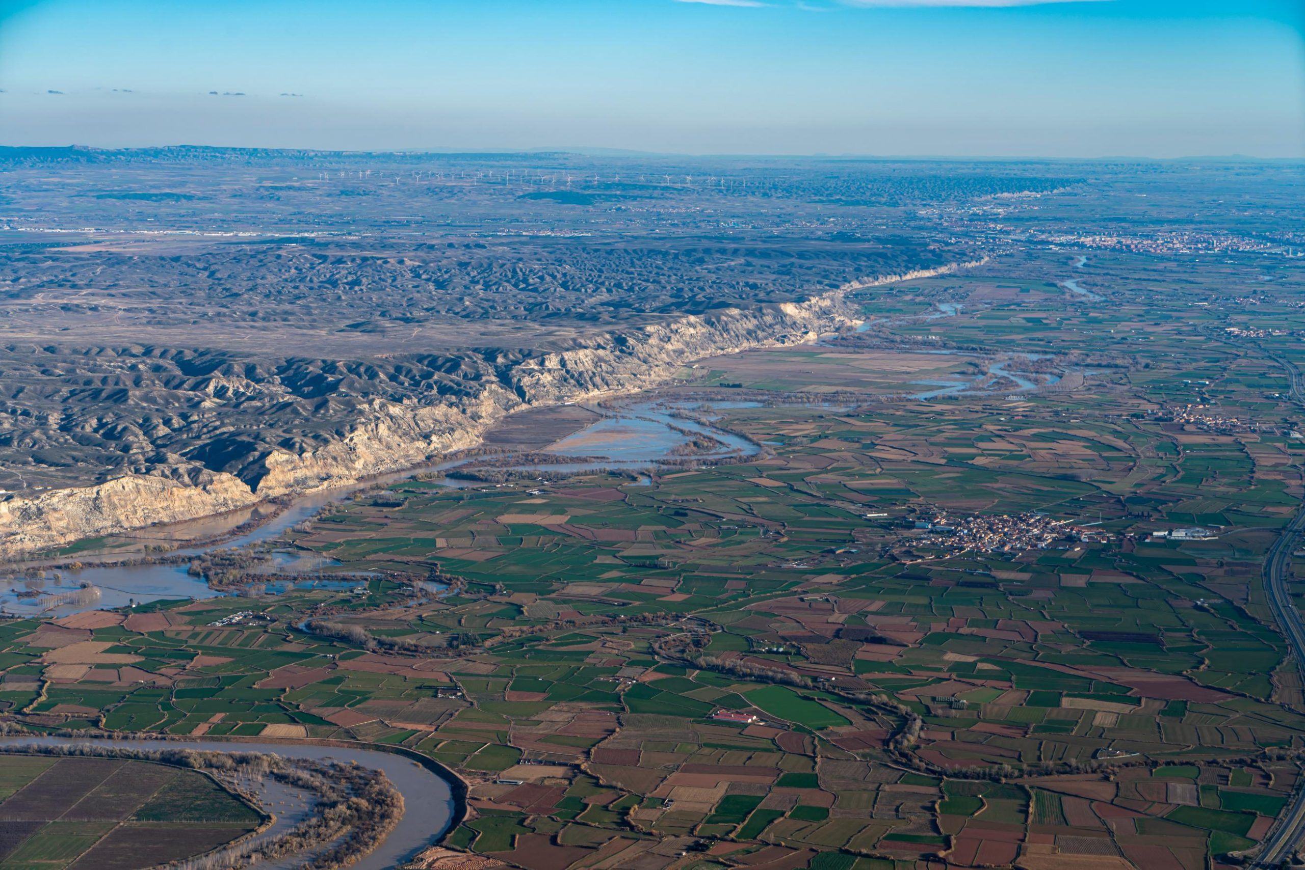
The stretch of the Ebro River between the bridge of the A-126 road over the Ebro River, in Alagón, and the beginning of the municipality of Utebo is a large alluvial plain1 that has pleasantly received the fertile sediments of the Ebro and Jalón Rivers.
The Ebro River in this section tends to diverge to the north, flowing against the gypsiferous escarpment2 (Figure 1), leaving a succession of stepped terraces on its right bank.
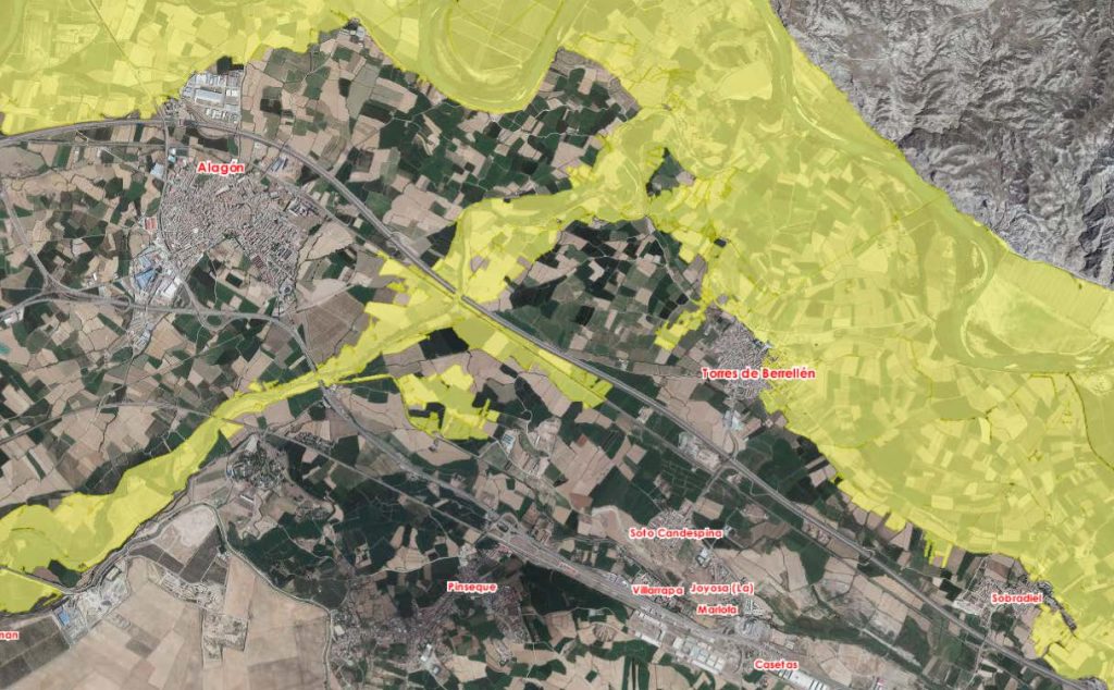
The localities in the area are distributed along these fluvial terraces3 , with those located on the lower terraces and of more recent conformation4 , Torres de Berrellén and Sobradiel, suffering the greatest risk of flooding. The urban centers of Alagón, La Joyosa, Pinseque and Casetas are located on higher terraces and, therefore, have a lower probability of flooding.
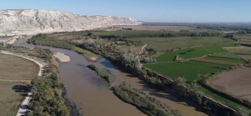
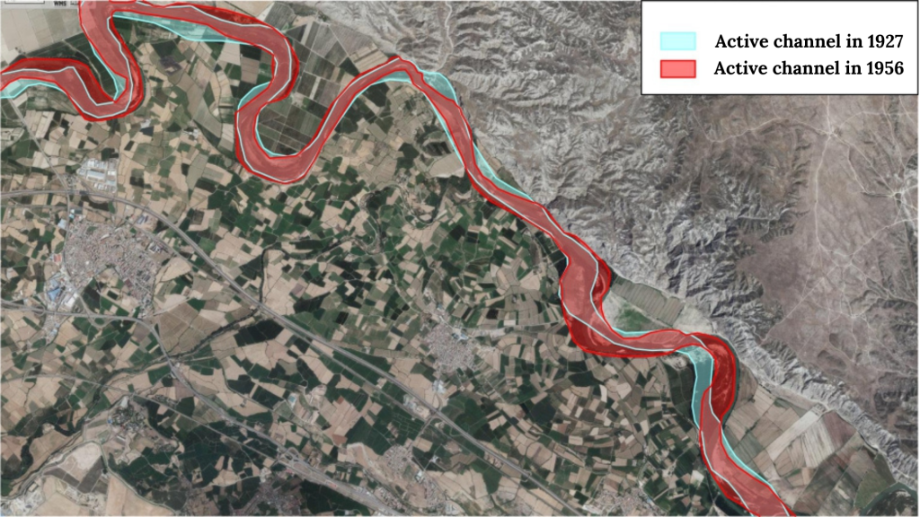
In its struggle against the escarpment, the Ebro has caused landslides and encountered harder areas that make it retreat towards the terrace, generating meanders of various sizes that are confined against the escarpment, often accessible only by water. These meanders, located on the left bank, have undergone changes in size and shape with the passage of time and successive floods, and their variations have been reflected in the shapes of the opposite bank (Figure 2).
With the beginning of the construction of flood defense works, carried out during the 1960s to 1990s (mainly defense dikes, breakwaters and jetties), a struggle began between the owners of the land located on both banks of the river to fix and stabilize its banks and prevent the river from moving towards the farms.
The success of these works has been limited, since they have only been able to defend the farms against small floods (less than the maximum ordinary flood) and, as a toll, both banks have had a pronounced “dam effect” that prevents the overflowing waters from returning to the main channel, increasing the damage.
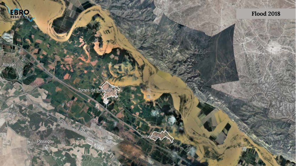
In major floods, the river breaks through the defenses on both banks. As the left bank is dominated by the escarpment, the waters overflow onto the lower terraces of the right bank. The extent of the flooded surface area depends on the flow of water in the river, the time duration of the episode and the section of the defense where the failure occurs, but since it is an appreciably flat plain, it is common for the water to occupy a large area (see Figure 3).
Alagón, La Joyosa, Pinseque and Casetas
The towns of Alagón, La Joyosa and Pinseque are located on the right bank of the Ebro. As mentioned above, they are located on older river terraces, at a level that prevents overflowing waters from reaching these urban centers (Figure 4), even for floods with a high return period (over 500 years, according to studies by the National Floodplain Mapping System).
Torres de Berrellén
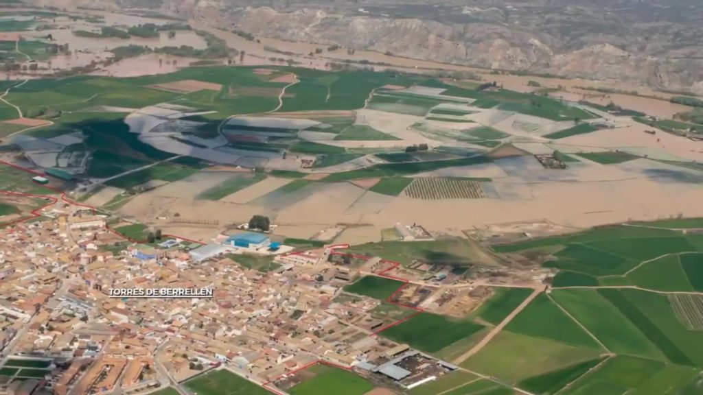
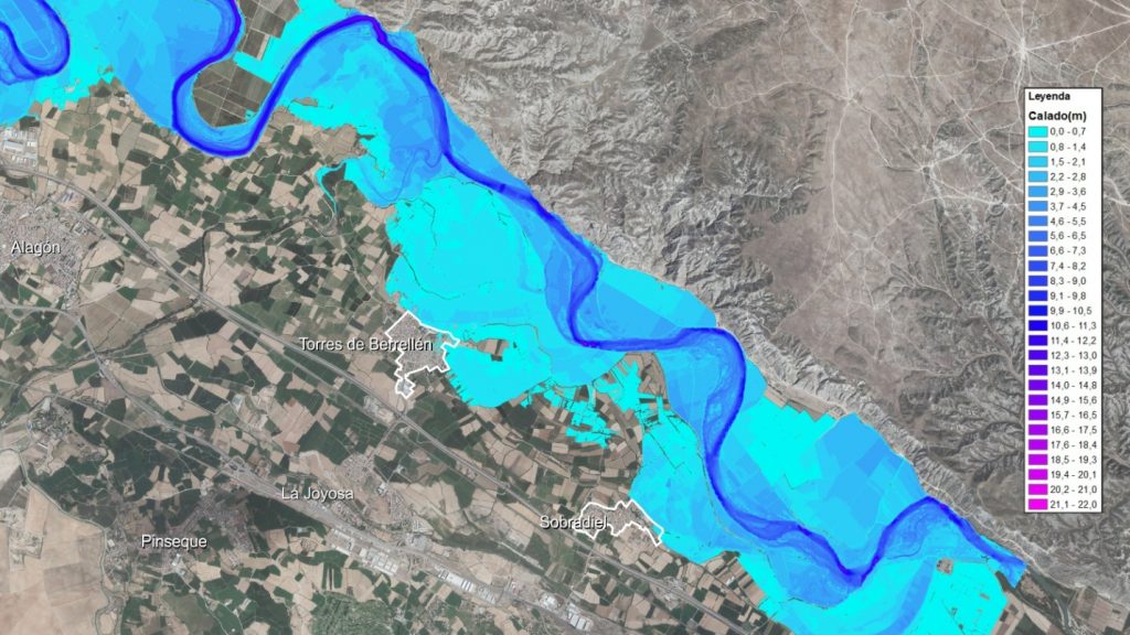
The town of Torres de Berrellén is located on a change of alluvial terrace, so that most of the town sits on the upper terrace and the northeastern area is located on the lower terrace, gradually descending from 215 m above sea level to 211 m above sea level approximately. In major floods, the lower area of the locality is susceptible to being reached by the overflowing waters.
In addition, the topographic configuration of the terrain reflects that an ancient meander of the river flowed close to the lower part of the urban center. Therefore, the overflow waters converge in this area, as it is the lowest part of the terrace, regardless of whether the overflow occurs upstream or downstream of the town.
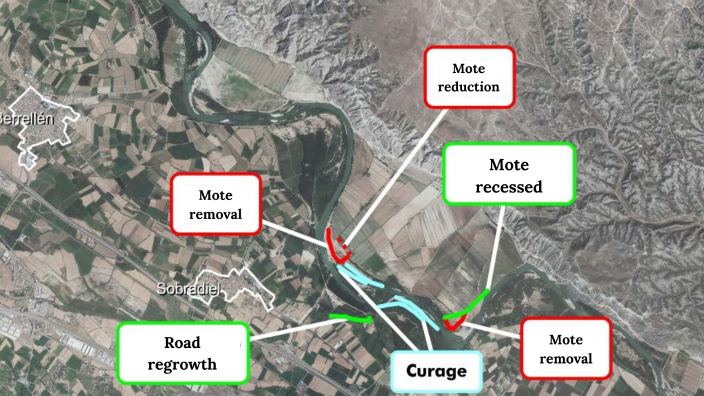
After the major floods of 2015 and 2018, protection works were undertaken in the urban core, through the regrowth and leveling of two roads that make up the safety perimeter of the urban core (Figure 6).
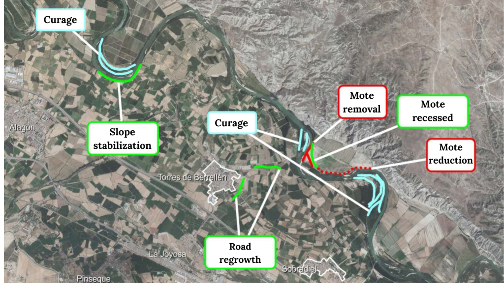
In the Ebrosoto estate, which occupies the meander on the opposite side of the town, several recesses and reductions were made in the existing defenses. También se han acometido trabajos de permeabilización (curage) de varios sotos situados en la orilla derecha e izquierda del río. Finally, the slope in the Pleidora area was smoothed and stabilized (Figure 6).
Currently, and in spite of the interventions carried out, the population of Torres de Berrellén is vulnerable to floods with a return period of 25 years, according to the hydraulic studies carried out.
Sobradiel
Sobradiel’s situation is similar to that of Torres. The urban area borders a lower terrace that tends to accumulate overflowing water. In this case, the locality is protected from overflows coming from upstream by a road with an adjoining ditch that is elevated above the ground.
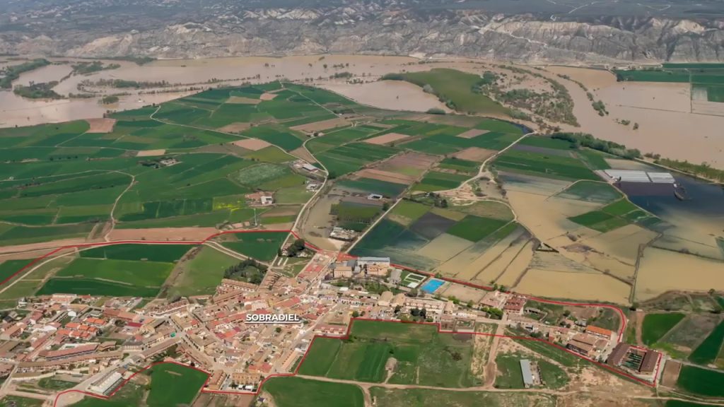
Following the 2015 and 2018 floods, the overall flow of the section was improved by making several setbacks and recesses in the defenses of the Soto Candespina meander, located on the opposite bank of the town. Also, two groves on the left and right banks have been permeabilized (curage technique). Finally, in 2019, the road around the perimeter of the drainage channel was widened to prevent flood waters from overflowing into the town (Figure 8).
At present, the Sobradiel locality is vulnerable to floods with a return period of 25 years, according to the hydraulic studies carried out.
Objectives of the study
Within the scope of the Ebro Resilience Strategy, a total of 260 kilometers of the Ebro River are being studied, divided into 15 sections.
Section 9 focuses on the towns of Torres de Berrellén and Sobradiel, since the urban areas of Alagón, La Joyosa, Pinseque and Casetas are outside the flood zone. The section studied runs from upstream of the A-126 road bridge over the Ebro river, in Alagón, and the beginning of the municipality of Utebo, with an approximate length of 25 km.
In accordance with the Ebro Resilience Strategy, the specific objectives of the study were as follows:
- To evaluate the level of protection of the urban areas of Torres de Berrellén and Sobradiel for floods with a return period of 25 years.
- Propose actions to prevent flooding, in the event of flooding.
- Reduce the risk of flooding in non-urban areas by reducing the speed at which water flows and/or the height that floods reach over fields.
Work performed
For the preparation of the study, a series of technical studies have been carried out using the latest available technologies, which have made it possible to evaluate the current situation of the section with respect to the objectives set. Once the current situation has been evaluated, different alternatives for action have been studied, individually and in combination, selecting those that have produced the desired effects and discarding the less favorable or counterproductive ones.
Digital Terrain Model (DTM)
To begin the study, a digital terrain model (called a DTM) is made to reproduce the current situation. It is important that this DTM faithfully reproduces the conditioning factors of the river section under analysis, and for this purpose the work listed below has been carried out.
First, the terrain is reproduced on a large scale, using LIDAR topography, which consists of a scan of the terrain using aerial means (normally a light aircraft is used for large areas, but drones are commonly used).
Next, the topography of the most important elements for the study is obtained, such as: the crest of the dikes, walls, breakwaters, bridges, drains, relief channels, safety perimeters, etc. This work has been carried out using classical surveying methods, increasing the accuracy of the data on these key elements.
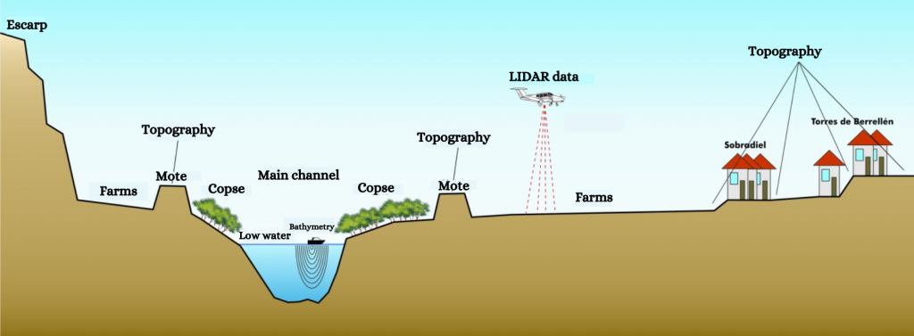
The above methods have the disadvantage that they are not able to obtain data from the ground beneath the water. This has been the main drawback encountered in previous flood studies. Technology is now available to obtain the topography of the river bed in a continuous manner. As a novelty for these studies carried out within the framework of the Ebro Resilience Strategy, aquatic means equipped with sonar have been used to collect bathymetric data from the bed of the riverbed, incorporating these data into the study.
The data obtained are combined for the elaboration of the digital terrain model.
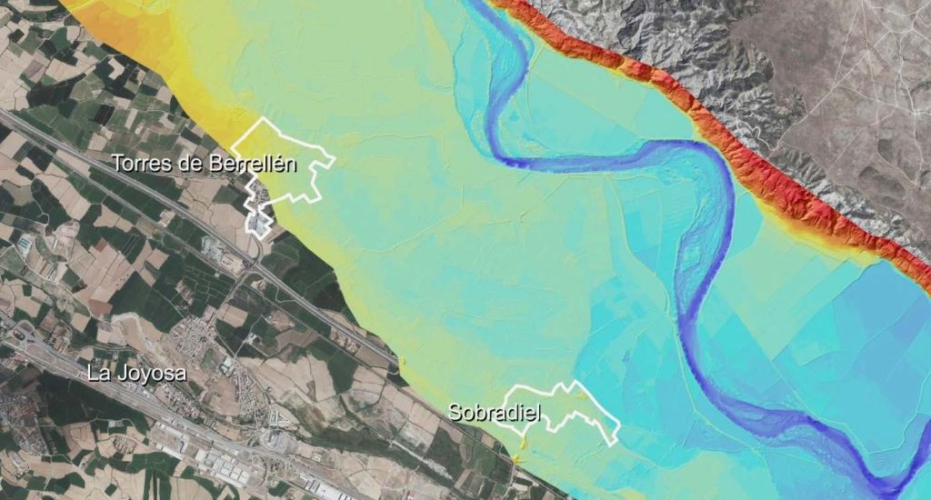
The DTM analysis has corroborated that, in the case of the two towns, there is land at a lower elevation adjacent to their urban centers. Therefore, the overflow waters flow towards these areas, as they are the deepest in the terrace, regardless of whether the overflow occurs upstream or downstream of the town.
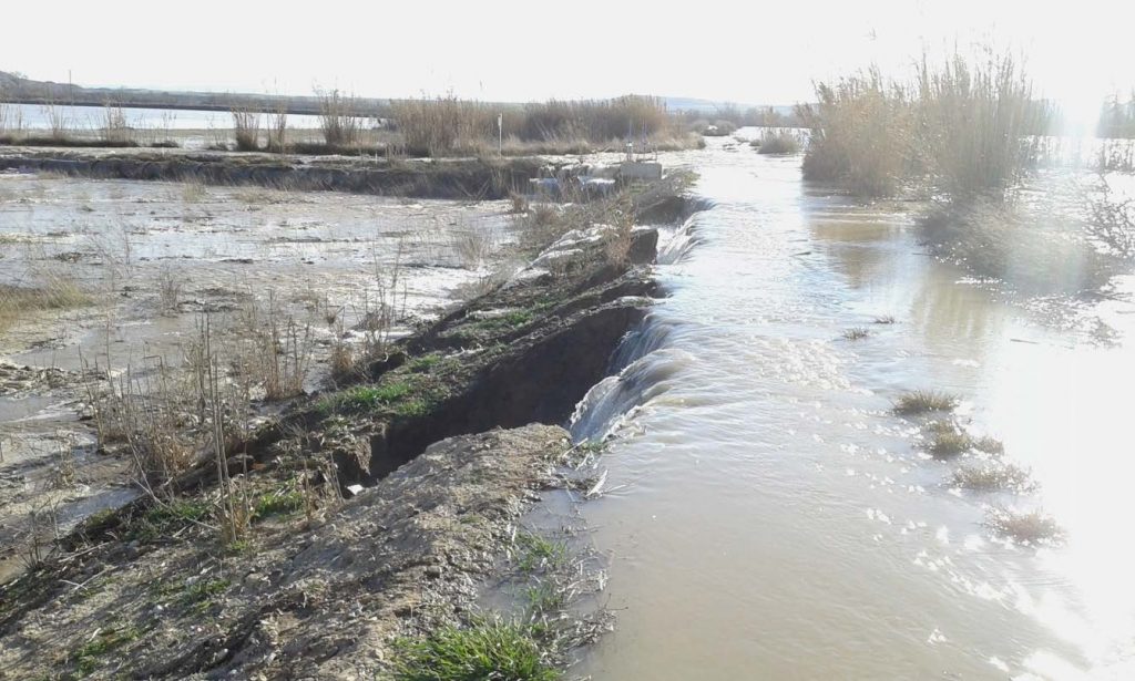
This circumstance makes it difficult to manage flooding in the stretch. Flood defense levees are by definition fungible structures. As they are made up of earthy materials, when they are overtopped by water, the water erodes their backdrop (Figure 11). Erosion progresses towards the inner part of the levee and usually leads to the collapse of the structure.
In addition to the above, the dams, in general, are structures built in several phases, with the materials available in the environment at the time of construction (sediments from the river itself, nearby dumps and clearing, debris, etc.), without foundations, supported on filtering materials and without adequate quality control in their execution. They are also located in a natural environment, where there are animals that nest inside and plants that take root in their slopes.
Consequently, a mote or levee can fail during a flood event without being overtopped by the floodwaters.
For the analysis of the hydraulic models, it must be considered that there is an 8 km linear front of dikes, whose overflow or collapse will direct the waters towards one of the two urban centers.
Hydraulic model
The next step of the study is the analysis of flooding episodes. Hydraulic models are used for this work, which consist of a computer tool that applies a given flow rate to the DTM and reproduces the effects of flooding.
These computer tools require a process called calibration to adjust the results obtained to the characteristics of the section under study. In this case, the aerial photos of the avenue from April 2018 and December 2019 were used, achieving a good calibration.
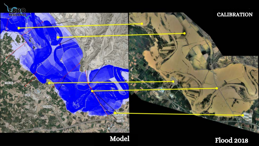
Once the hydraulic model has been configured and calibrated, the target flood is reproduced, in this case the one corresponding to a return period of 25 years, which in this section is equivalent to a flow of 2,600 m3/s, and the effects produced are analyzed.
With respect to the problems that may be caused by possible overflows, it should be borne in mind that the hydraulic model considers the terrain to be rigid, i.e., the motes do not collapse at any time even if they are overflowed. To compensate for this circumstance, the flood peak in the simulation will be prolonged in time, achieving effects similar to those produced in a real event.
Study alternatives
In the analysis of the simulation of the target flood (2,600 m3/The first overflow is detected downstream of the A-126 road bridge on the right bank, which is contained in the Pleidora area as it is an elevated terrace 7 meters above the flooded area.
Then there is a second overflow on the right bank that is contained by the elevated irrigation ditches that run to the right of the Jalón River. The guarantee of this containment is subject to the structural resistance of the ditches.
Downstream from the mouth of the Jalón, in the defense in front of the town of Torres de Berrellén, three overflows occurred that ended up reaching the town. The first, temporally speaking, originates in the downstream area of El Plano (navy blue arrows in Figure 13). The overflowing waters flow upstream, in a westerly direction, and end up reaching the urban area of Torres de Berrellén. The second point of overflow is the frontal motte to the locality (yellow arrows in Figure 13). In this case, the relief is less favorable and flooding reaches the urban area more slowly. Finally, the Jalón irrigation ditches are overflowed and the overflow produced upstream is added to the frontal one and reaches the town on its north side (red arrows in figure 13).
In the case of Sobradiel, a first overflow occurs downstream of the town, in the area where the scorredero flows into the river. The waters flow in a westerly direction, through the
The deeper terraces, up to the locality, surround it on its northeastern side (white arrows in Figure 13). In the northern area, the overflow that initially occurs (navy blue arrows in Figure 13) is contained on its way to Sobradiel by the road and the irrigation ditch near the San Antonio hermitage. However, for flows of around 2,600 m3/s, at the limit of the target flood, both overflows occur and the waters end up reaching the population (green arrows in Figure 13).
Once the data obtained have been used to determine the problems identified in advance, several alternatives with different actions are simulated. For each alternative studied, the DTM is modified, incorporating the hypothetical actions to be undertaken, and the target flood is reproduced again on the modified terrain, comparing the results obtained with the previous ones and evaluating whether the expected improvement is achieved. If this is not the case, the proposal is rejected. The actions that do prove to be favorable to the objectives pursued are also simulated in a combined form, to check whether their integrated effect is more favorable, neutral or whether the proposals cancel each other out.
In this section, alternatives aimed at reducing overflow points or the amount of overflowing water have been proposed. First, actions have been studied to eliminate the narrowing caused by the defenses located on the right bank. The total elimination of the defenses protecting the cultivated meanders close to the escarpment on the left bank was then studied.
None of these alternatives manages to prevent the waters from reaching the town of Torres de Berrellén. For this reason, an additional alternative is proposed, which consists of completing the current security perimeter by surrounding the town on its northern and eastern fronts.
In the case of Sobradiel, the overflow that ends up reaching the urban area can be avoided for the target flows by setting back the mote located downstream of the overflow, in the area of El Carrizal, which raises the height of the sheet of water, causing the defense to overflow. However, the safety of the population would depend on the structural integrity of the defenses, which are located at a great distance from the urban area, making it difficult to inspect them during flood episodes and could cause safety problems for the operators carrying out these inspections, since there is no guaranteed return path. For this reason, the construction of a security perimeter that delimits the town to the north and east has also been considered.
Finally, the alternative that has been shown to be the most efficient in the simulations is a combination of interventions as follows (Figure 14):
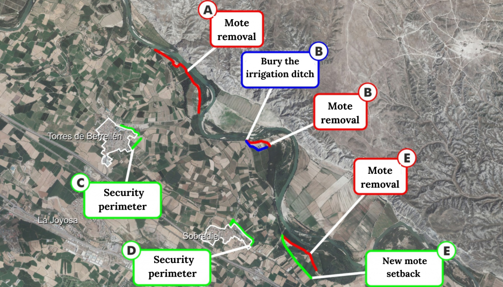
- Elimination of the narrowing that occurs in front of the town of Torres de Berrellén through the removal of the poplar grove’s defensive mound.
- Elimination of the narrowing produced by the defense mote and the irrigation ditch of the Tambor poplar grove. It is proposed to remove the mote and bury the irrigation ditch.
- Expansion of the current security perimeter of Torres de Berrellén, surrounding the town on its northern and eastern fronts.
- Construction of a security perimeter for the urban area of Sobradiel on the northeast side.
- Elimination of the narrowing that diverts the waters towards Sobradiel by removing the defense mote in the area of El Carrizal and its construction recessed to the edge of the upper terrace.
Conclusion
The alternative selected as the most efficient would prevent the flooding of the urban centers of Torres de Berrellén and Sobradiel for floods with a return period of 25 years, achieving the objectives set out in the Ebro Resilience Strategy.
In addition to the above, with the improvement in water flow that would be achieved, for the 10-year return period flood, 96 ha of agricultural plots that are now flooded would cease to be flooded (14% of the farms in the section) and the height of the water over the fields would decrease in 81% of the farms in the section under study. Thus, 95% of the agricultural plots under study would see their flooding conditions improved.
The study has a pre-project level, being determined to select the most suitable alternatives and to allow the environmental evaluation of the proposed solutions. The definition of the exact dimensions of the actions to be carried out and their details must be included in the corresponding construction project.
The execution of these actions must be associated with a follow-up of their evolution that will make it possible to verify that the objectives pursued are achieved.
What’s next?
The alternative selected as the most efficient would prevent the flooding of the urban centers of Torres de Berrellén and Sobradiel for floods with a return period of 25 years, achieving the objectives set out in the Ebro Resilience Strategy.
In addition to the above, with the improvement in water flow that would be achieved, for the 10-year return period flood, 96 ha of agricultural plots that are now flooded would cease to be flooded (14% of the farms in the section) and the height of the water over the fields would decrease in 81% of the farms in the section under study. Thus, 95% of the agricultural plots under study would see their flooding conditions improved.
The study has a pre-project level, being determined to select the most suitable alternatives and to allow the environmental evaluation of the proposed solutions. The definition of the exact dimensions of the actions to be carried out and their details must be included in the corresponding construction project.
The execution of these actions must be associated with a follow-up of their evolution that will make it possible to verify that the objectives pursued are achieved.
1Formedby sediments from a river.
2Composedof rocks containing gypsum.
3Shapedby the passage of a river.
4Termexpressed in geological times and not on a human scale.
5Structureformed with earth, in the form of an embankment, whose predominant dimension is longitudinal and that protects from frontal overflow. Locally known as motes.
6Structurebuilt on the bank of a river or on the coast of the sea, which protrudes perpendicular to it and whose function is to defend the banks or modify the current.
7Structuremade up of large stone blocks.
8Themaximum ordinary flood is the average of the maximum annual floods for a minimum period of ten years.
9Theeffect or paradox of the levee occurs when these structures are overtopped by the overflowing waters and prevent the waters from returning to the main channel, obtaining the opposite result to that intended.
10Heightabove sea level in Alicante.
11Averagetime taken to produce a flood of similar flow rate
12Metersabove sea level in Alicante.
13Theequivalent of a terrain model but in a digital environment.
14An acronymfor Light Detection and Ranging or Laser Imaging Detection and Ranging.
15Elementthat obtains the depth of the bottom of the sea or a river by emitting sounds and measuring their reflection.
16Topographymade underwater.
17Healthnot exposed to water.
18Theequivalent of pouring water into the model.